Researchers from the University of Alicante have created the first collapse probability map for reinforced concrete buildings in peninsular Spain. This map, which is part of the final outcomes of Proyecto RETOS2016: Escenarios de movimiento del suelo enfocado hacia el riesgo sísmico. Aplicación a escenarios de daños, pérdidas y planes de emergencia [RETOS2016 Project: Seismic risk-targeted ground motion scenarios. Application to scenarios of damages, losses and emergency plans] (CGL2016-77688-R), is included in the activities of the EU-funded H2020 TURNkey Project: Towards more Earthquake-resilient Urban Societies through a Multi-sensor-based Information System enabling Earthquake Forecasting, Early Warning and Rapid Response actions (grant agreement No 821046).
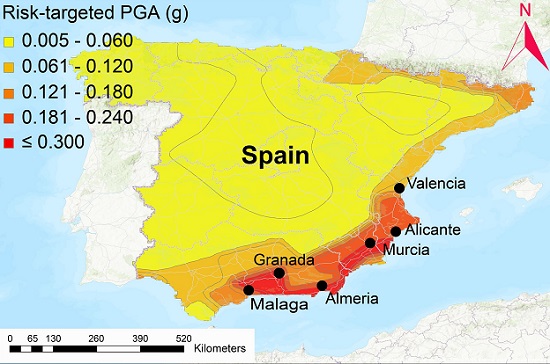
Researchers Alireza Kharazian, Sergio Molina, Juan J. Galiana and Noelia Agea, from the Multidisciplinary Institute for Environmental Research (IMEM), first obtained an updated seismic hazard map for Spain. Based on this, and taking building fragility into account, they analysed how collapse probability behaves and represented this information in the form of a risk coefficient map. The map and the study findings were published on 29 July in the article Risk-targeted hazard maps for Spain, which appeared in the scientific journal Bulletin of Earthquake Engineering.
The authors observed that the probability of collapse depends not only on the design PGA value, currently set out in the applicable regulations on seismic resistance, but also on the shape of the seismic hazard curve. After analysing the cities with the highest seismic hazard in Spain, the researchers noted that the design PGA value should be increased in all of them to reduce the probability of collapse. The highest increase should take place in Murcia followed by Alicante, which could help explain the considerable damage caused in Lorca after the 2011 earthquake. The study also received funding and support from Alicante and Elche city councils.
In 2022, the UA and the Valencia Region Safety and Emergency Response Agency will lead a “proof of concept” test in Alicante province to demonstrate the usefulness of the scientific algorithms and the seismic emergency management platform currently under development within the TURNkey project.
Bibliographic reference:
Kharazian, A., Molina, S., Galiana-Merino, J.J. et al. Risk-targeted hazard maps for Spain. Bull Earthquake Eng (2021).
Fuente: www.ua.es